
Carlton topographic map
Interactive map
Click on the map to display elevation.
About this map
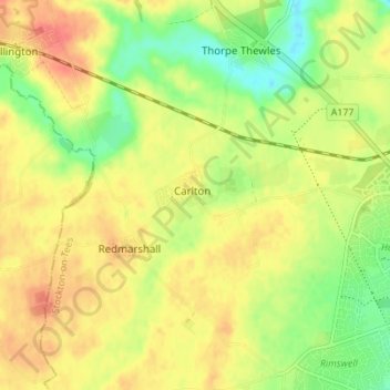
Name: Carlton topographic map, elevation, terrain.
Average elevation: 45 m
Minimum elevation: 18 m
Maximum elevation: 67 m
Other topographic maps
Click on a map to view its topography, its elevation and its terrain.
Carlton
United Kingdom > England > Carlton
Carlton, Cambridgeshire, East of England, England, CB8 9JY, United Kingdom
Average elevation: 105 m