
Madhya Pradesh topographic map
Interactive map
Click on the map to display elevation.
About this map
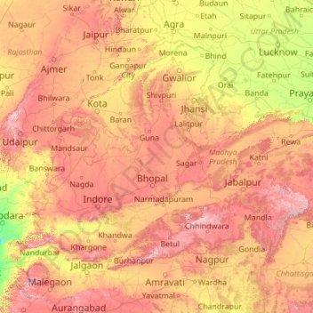
Name: Madhya Pradesh topographic map, elevation, terrain.
Location: Madhya Pradesh, India (21.07069 74.03030 26.86956 82.81261)
Average elevation: 347 m
Minimum elevation: 15 m
Maximum elevation: 1,313 m
Madhya Pradesh literally means "Central Province", and is located in the geographic heart of India in between the latitude of 21.6°N–26.30°N and longitude of 74°9'E–82°48'E. The state straddles the Narmada River, which runs east and west between the Vindhya and Satpura ranges; these ranges and the Narmada are the traditional boundaries between the north and south of India. The highest point in Madhya Pradesh is Dhupgarh, with an elevation of 1,350 m (4,429 ft).
Other topographic maps
Click on a map to view its topography, its elevation and its terrain.
Bengaluru
India > Karnataka > Bangalore North
Bengaluru, Bangalore North, Bengaluru Urban District, Karnataka, India
Average elevation: 881 m
Chennai
India > Tamil Nadu > Chennai
Chennai, Chennai District, Tamil Nadu, India
Average elevation: 8 m
Bachupally mandal
Bachupally mandal, Medchal–Malkajgiri District, Telangana, 500090, India
Average elevation: 593 m
North Sentinel Island
India > Andaman and Nicobar Islands > Ferrargunj
North Sentinel Island, Ferrargunj, South Andaman District, Andaman and Nicobar Islands, India
Average elevation: 20 m
Western Ghats
Western Ghats, Idukki, Kerala, 685614, India
Average elevation: 2,225 m
Pune
India > Maharashtra > Pune City > Pune
Pune, Pune City, Pune District, Maharashtra, 411001, India
Average elevation: 641 m
3d
India > Rajasthan > Ganganagar Tehsil > 1 LNP
3d, 1 LNP, Ganganagar Tehsil, Sri Ganganagar District, Rajasthan, India
Average elevation: 178 m
Kolkata
Kolkata, Kolkata District, West Bengal, 700073, India
Average elevation: 5 m
Gurgaon
India > Haryana > Gurugram District
Gurgaon, Gurugram District, Haryana, India
Average elevation: 237 m
Mysuru
India > Karnataka > Mysuru taluk
Mysuru, Mysuru taluk, Mysuru District, Karnataka, 570001, India
Average elevation: 727 m
Indore
India > Madhya Pradesh > Juni Indore Tahsil
Indore, Juni Indore Tahsil, Indore District, Madhya Pradesh, 452001, India
Average elevation: 555 m
Kanchanpur
India > Madhya Pradesh > Karkeli Tahsil
Kanchanpur, Karkeli Tahsil, Umaria District, Madhya Pradesh, India
Average elevation: 500 m
Thuneri
India > Tamil Nadu > Udhagamandalam
Thuneri, Udhagamandalam, Nilgiris District, Tamil Nadu, 643402, India
Average elevation: 1,899 m
Tharangambadi
Tharangambadi, Mayiladuthurai District, Tamil Nadu, India
Average elevation: 5 m
Hosur
India > Tamil Nadu > Hosur
Hosur, Krishnagiri District, Tamil Nadu, 635109, India
Average elevation: 859 m
Kodaikanal
Kodaikanal, Dindigul District, Tamil Nadu, India
Average elevation: 869 m
Vijayawada
India > Andhra Pradesh > Vijayawada (Urban)
Vijayawada, Vijayawada (Urban), NTR District, Andhra Pradesh, 520001, India
Average elevation: 36 m
Prayagraj
India > Uttar Pradesh > Prayagraj
Prayagraj, Prayagraj District, Uttar Pradesh, 211001, India
Average elevation: 91 m
Coimbatore
India > Tamil Nadu > Coimbatore North
Coimbatore, Coimbatore North, Coimbatore District, Tamil Nadu, 641001, India
Average elevation: 452 m
Patna
India > Bihar > Patna Rural
Patna, Patna Rural, Patna District, Bihar, 800001, India
Average elevation: 51 m