
Yellowstone Lake topographic map
Interactive map
Click on the map to display elevation.
About this map
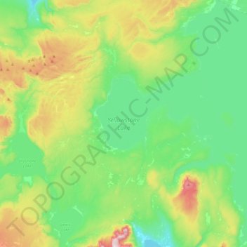
Name: Yellowstone Lake topographic map, elevation, terrain.
Location: Yellowstone Lake, Teton County, Wyoming, United States (44.27663 -110.58115 44.56399 -110.20122)
Average elevation: 2,453 m
Minimum elevation: 2,270 m
Maximum elevation: 2,926 m
The lake has been known by various names as depicted on early maps and in journals. Both fur trader David Thompson and explorer William Clark referred to the lake as Yellow Stone. Osborne Russell referred to the lake as Yellow Stone Lake in his 1834 journal. On some William Clark maps, the lake has the name Eustis Lake and the name Sublette's Lake was also used to name the lake in the early 19th century. The name Yellowstone Lake appears formally first in the 1839 maps of the Oregon Territory by U.S. Army topographical engineer, Captain Washington Hood and has remained so since that time.
Other topographic maps
Click on a map to view its topography, its elevation and its terrain.
Grand Teton National Park
United States > Wyoming > Teton County
Grand Teton National Park, Teton County, Wyoming, United States
Average elevation: 2,409 m
Teton Village
United States > Wyoming > Teton County
Teton Village, Teton County, Wyoming, 83025, United States
Average elevation: 2,144 m
Pacific Creek
United States > Wyoming > Teton County
Pacific Creek, Teton County, Wyoming, United States
Average elevation: 2,434 m
Isa Lake
United States > Wyoming > Teton County
Isa Lake, Teton County, Wyoming, United States
Average elevation: 2,503 m
Rocky Mountains
United States > Wyoming > Teton County
Rocky Mountains, Teton County, Wyoming, United States
Average elevation: 2,292 m
Jackson
United States > Wyoming > Teton County
Jackson, Teton County, Wyoming, 83002, United States
Average elevation: 2,043 m
Disappointment Peak
United States > Wyoming > Teton County
Disappointment Peak, Teton County, Wyoming, United States
Average elevation: 3,255 m
Moran
United States > Wyoming > Teton County > Moran
Moran, Teton County, Wyoming, United States
Average elevation: 2,088 m
Upper Geyser Basin
United States > Wyoming > Teton County > Upper Geyser Basin
Upper Geyser Basin, Teton County, Wyoming, United States
Average elevation: 2,295 m
Buck Mountain
United States > Wyoming > Teton County
Buck Mountain, Teton County, Wyoming, United States
Average elevation: 3,128 m
Grand Teton
United States > Wyoming > Teton County
Grand Teton, Teton County, Wyoming, United States
Average elevation: 3,330 m