
Roosevelt Island topographic map
Interactive map
Click on the map to display elevation.
About this map
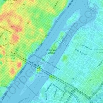
Name: Roosevelt Island topographic map, elevation, terrain.
Average elevation: 13 m
Minimum elevation: -6 m
Maximum elevation: 52 m
Other topographic maps
Click on a map to view its topography, its elevation and its terrain.
Manhattan
United States > New York > New York County > New York
Manhattan, New York County, New York, United States
Average elevation: 16 m
Central Park
United States > New York > New York County > New York
Central Park, New York County, New York, United States
Average elevation: 26 m
Governors Island
United States > New York > New York County > New York
Governors Island, Manhattan, New York County, New York, United States
Average elevation: 1 m
Battery Park
United States > New York > New York County > New York
Battery Park, Financial District, Manhattan, New York County, New York, 10004, United States
Average elevation: 3 m
Highbridge Park
United States > New York > New York County > New York
Highbridge Park, Manhattan, New York County, New York, United States
Average elevation: 30 m
Manhattan Community Board 3
United States > New York > New York County > New York
Manhattan Community Board 3, Manhattan, New York County, New York, United States, Seward Park
Average elevation: 10 m
Hunter’s Point South Waterfront Park
United States > New York > New York County > New York
Hunter’s Point South Waterfront Park, Manhattan Community Board 6, Manhattan, New York County, New York, United States
Average elevation: 5 m