
Lake Arenal topographic map
Interactive map
Click on the map to display elevation.
About this map
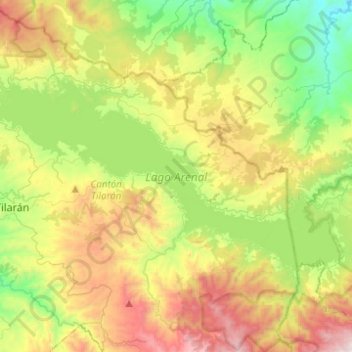
Name: Lake Arenal topographic map, elevation, terrain.
Average elevation: 687 m
Minimum elevation: 100 m
Maximum elevation: 1,615 m
Other topographic maps
Click on a map to view its topography, its elevation and its terrain.
Arenal Volcano
Costa Rica > Cantón San Carlos > La Fortuna
Arenal Volcano, La Fortuna, Cantón San Carlos, Alajuela Province, 21007, Costa Rica
Average elevation: 1,014 m