
Pilanesberg National Park topographic map
Interactive map
Click on the map to display elevation.
About this map
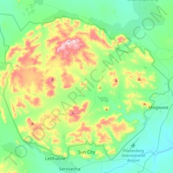
Name: Pilanesberg National Park topographic map, elevation, terrain.
Average elevation: 1,186 m
Minimum elevation: 1,001 m
Maximum elevation: 1,683 m
Other topographic maps
Click on a map to view its topography, its elevation and its terrain.
Mankwe
South Africa > North West > Bojanala Platinum District Municipality > Moses Kotane Local Municipality
Mankwe, Moses Kotane Local Municipality, Bojanala Platinum District Municipality, North West, South Africa
Average elevation: 1,170 m