
Communauté urbaine d'Édéa topographic map
Interactive map
Click on the map to display elevation.
About this map
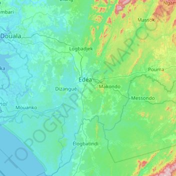
Name: Communauté urbaine d'Édéa topographic map, elevation, terrain.
Location: Communauté urbaine d'Édéa, Sanaga-Maritime, Cameroon (3.25690 9.86322 4.24455 10.49099)
Average elevation: 109 m
Minimum elevation: -2 m
Maximum elevation: 1,054 m
Other topographic maps
Click on a map to view its topography, its elevation and its terrain.
Ikem
Cameroon > Sanaga-Maritime > Ngambé
Ikem, Ngambé, Sanaga-Maritime, Cameroon
Average elevation: 704 m