
River Tay topographic map
Interactive map
Click on the map to display elevation.
About this map
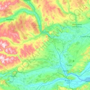
Name: River Tay topographic map, elevation, terrain.
Location: River Tay, Perth and Kinross, Scotland, United Kingdom (56.35482 -4.00259 56.66102 -3.29671)
Average elevation: 213 m
Minimum elevation: -1 m
Maximum elevation: 801 m
Perth and Kinross trails, hiking, mountain biking, running and outdoor activities
Other topographic maps
Click on a map to view its topography, its elevation and its terrain.
Ben Lawers
United Kingdom > Scotland > Perth and Kinross
Due to its high elevation and underlying geology, Ben Lawers is home to an exceptionally rich selection of arctic-alpine plant species and habitats. Since 1964, it has been designated as a National Nature Reserve (NNR).
Average elevation: 849 m
Ben Vorlich
United Kingdom > Scotland > Perth and Kinross
Due to its prominence when seen from the lower ground of the Central Belt, Ben Vorlich is one of the most commonly seen of Munros, Scotland's peaks of at least 3,000 ft (914.4 m) elevation. It lies in an area of land bounded to the north by Loch Earn and to the west by Loch Lubnaig. The town of Callander lies…
Average elevation: 646 m
Craig Varr
United Kingdom > Scotland > Perth and Kinross > Kinloch Rannoch > Drumchastle
Average elevation: 370 m
The Birks of Aberfeldy
United Kingdom > Scotland > Perth and Kinross > Aberfeldy
Average elevation: 222 m
Glen Shee
United Kingdom > Scotland > Perth and Kinross > Spittal of Glenshee
The A93 road, part of General Wade's military road from Perth to Fort George, runs north through the glen and on into Glen Beag, where it crosses the Cairnwell Pass, which at an elevation of 2,200 feet (670 metres) is the highest public road in the UK. The road climbing to the summit is now wide and straight…
Average elevation: 387 m
Easter Balgedie
United Kingdom > Scotland > Perth and Kinross > Kinnesswood > Easter Balgedie
Average elevation: 189 m