
Sarnia topographic map
Interactive map
Click on the map to display elevation.
About this map
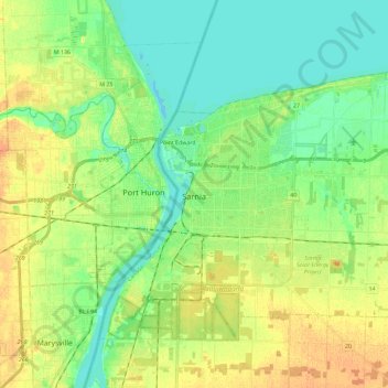
Name: Sarnia topographic map, elevation, terrain.
Location: Sarnia, Lambton County, Ontario, Canada (42.91182 -82.46010 43.03856 -82.22987)
Average elevation: 186 m
Minimum elevation: 173 m
Maximum elevation: 202 m
Sarnia is located on the eastern shore of Lake Huron at its extreme southern point where it flows into the St. Clair River. Most of the surrounding area is flat, and the elevation ranges from 169 metres (554 ft) and 281 metres (922 ft) above sea level. The soil mostly comprises clay. Despite this high percentage of clay, the soil is remarkably rich for cultivation. Prior to the Ice Age, glaciers covered most of the area, as can be seen not only by the existence of the Great Lakes themselves but also of alluvial sand deposits, terminal moraines, and rich oil reserves. The entire area was submerged and plant and animal matter formed many layers of sediment as they settled after the waters receded. Sarnia is not part of the Canadian Shield and is located just beyond its southernmost reaches, 280 kilometres (174 mi) west of Toronto and 90 kilometres (56 mi) north of Detroit.
Other topographic maps
Click on a map to view its topography, its elevation and its terrain.
Lambton Shores
Canada > Ontario > Lambton County
Lambton Shores, Lambton County, Southwestern Ontario, Ontario, Canada
Average elevation: 195 m
Wisbeach
Canada > Ontario > Lambton County > Warwick
Wisbeach, Warwick, Lambton County, Southwestern Ontario, Ontario, Canada
Average elevation: 251 m