
Alfred topographic map
Interactive map
Click on the map to display elevation.
About this map
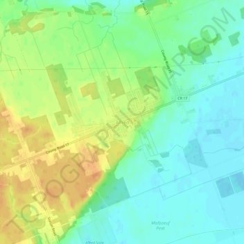
Name: Alfred topographic map, elevation, terrain.
Average elevation: 64 m
Minimum elevation: 49 m
Maximum elevation: 84 m
Other topographic maps
Click on a map to view its topography, its elevation and its terrain.
Lefaivre
Canada > Ontario > Prescott and Russell Counties > Alfred and Plantagenet
Lefaivre, Alfred and Plantagenet, Prescott and Russell Counties, Eastern Ontario, Ontario, K0B 1J0, Canada
Average elevation: 50 m
Wendover
Canada > Ontario > Prescott and Russell Counties > Alfred and Plantagenet > Wendover
Wendover, Alfred and Plantagenet, Prescott and Russell Counties, Eastern Ontario, Ontario, K0A 3K0, Canada
Average elevation: 49 m
Plantagenet
Canada > Ontario > Prescott and Russell Counties > Alfred and Plantagenet
Plantagenet, Alfred and Plantagenet, Prescott and Russell Counties, Eastern Ontario, Ontario, K0B 1L0, Canada
Average elevation: 61 m