
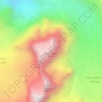
Mont Collon topographic map
Interactive map
Click on the map to display elevation.
About this map
Name: Mont Collon topographic map, elevation, terrain.
Location: Mont Collon, Evolène, Hérens, Valais/Wallis, 1983, Switzerland (45.97723 7.50767 45.97733 7.50777)
Average elevation: 2,966 m
Minimum elevation: 2,292 m
Maximum elevation: 3,678 m
Other topographic maps
Click on a map to view its topography, its elevation and its terrain.
Glacier du Mont Miné
Switzerland > Valais/Wallis > Evolène
Glacier du Mont Miné, Arolla - Cabane de la Tsa, Tsijiore Nouve, Evolène, Hérens, Valais/Wallis, 1983, Switzerland
Average elevation: 3,006 m
Glacier de Pièce
Switzerland > Valais/Wallis > Evolène
Glacier de Pièce, Arolla - Cabane de la Tsa, Tsijiore Nouve, Evolène, Hérens, Valais/Wallis, 1983, Switzerland
Average elevation: 2,895 m
Glacier de Montay
Switzerland > Valais/Wallis > Evolène
Glacier de Montay, Barrage de Ferpècle, Renoillin, Evolène, Hérens, Valais/Wallis, 1983, Switzerland
Average elevation: 2,835 m