
Pangong Tso topographic map
Interactive map
Click on the map to display elevation.
About this map
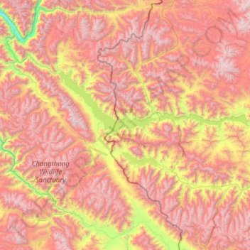
Name: Pangong Tso topographic map, elevation, terrain.
Location: Pangong Tso, Rutog County, Ngari Prefecture, Tibet, China (33.42971 78.41971 33.98425 79.93191)
Average elevation: 5,119 m
Minimum elevation: 3,493 m
Maximum elevation: 6,599 m
Pangong Tso or Pangong Lake (Tibetan: སྤང་གོང་མཚོ; Chinese: 班公错, Pinyin: Bān gōng cuò, Hindi: पैंगोंग झील) is an endorheic lake in the Himalayas situated at an elevation of 4,225 m (13,862 ft). It is 134 km (83 mi) long and extends from Ladakh, India to the Tibetan Autonomous Region, China. Approximately 60% of the length of the lake lies within the Tibetan Autonomous Region. The lake is 5 km (3.1 mi) wide at its broadest point. All together it covers 604 km2. During winter the lake freezes completely, despite being saline water. It is not a part of the Indus River basin area and geographically a separate landlocked river basin.
Other topographic maps
Click on a map to view its topography, its elevation and its terrain.
Kunlun Mountains
China > Tibet > Rutog County > Dongru
Kunlun Mountains, Dongru, Rutog County, Ngari Prefecture, Tibet, China
Average elevation: 6,188 m