
Faroe Islands topographic map
Interactive map
Click on the map to display elevation.
About this map
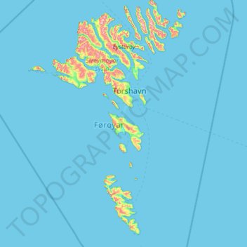
Name: Faroe Islands topographic map, elevation, terrain.
Location: Faroe Islands, Eysturoy region, Faroe Islands (61.33791 -7.68787 62.39430 -6.25363)
Average elevation: 26 m
Minimum elevation: -1 m
Maximum elevation: 841 m
The climate varies greatly over small distances, due to the altitude, ocean currents, topography and winds. Precipitation varies considerably throughout the archipelago. In some highland areas, snow cover can last for months with snowfalls possible for the greater part of the year (on the highest peaks, summer snowfall is by no means rare), while in some sheltered coastal locations, several years pass without any snowfall whatsoever. Tórshavn receives frosts more often than other areas just a short distance to the south. Snow is also seen at a much higher frequency than on outlying islands nearby. The area receives on average 49 frosts a year.
Other topographic maps
Click on a map to view its topography, its elevation and its terrain.
Nes, Eysturoy
Faroe Islands > Eysturoy region
Nes, Eysturoy, Eysturoy region, 655, Faroe Islands
Average elevation: 33 m
Eysturoy
Faroe Islands > Eysturoy region
Eysturoy, Eysturoy region, Faroe Islands
Average elevation: 162 m