
Valley Park topographic map
Interactive map
Click on the map to display elevation.
About this map
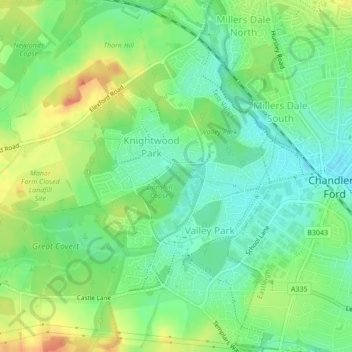
Name: Valley Park topographic map, elevation, terrain.
Average elevation: 37 m
Minimum elevation: 19 m
Maximum elevation: 61 m
Other topographic maps
Click on a map to view its topography, its elevation and its terrain.
Redenham
United Kingdom > England > Test Valley > Redenham
Redenham, Test Valley, Hampshire, South East, England, SP11 9AY, United Kingdom
Average elevation: 113 m
Romsey and Southampton North
United Kingdom > England > Test Valley
Romsey and Southampton North, Bossington, Test Valley, Hampshire, South East, England, United Kingdom
Average elevation: 75 m
Kimpton
United Kingdom > England > Test Valley
Kimpton, Test Valley, Hampshire, South East, England, United Kingdom
Average elevation: 111 m
Toot Hill
United Kingdom > England > Test Valley
Toot Hill, Test Valley, Hampshire, South East, England, SO16 8AL, United Kingdom
Average elevation: 45 m
Michelmersh and Timsbury
United Kingdom > England > Test Valley
Michelmersh and Timsbury, Test Valley, Hampshire, South East, England, United Kingdom
Average elevation: 46 m
River Dever
United Kingdom > England > Test Valley
River Dever, Test Valley, Hampshire, South East, England, SO21 3QG, United Kingdom
Average elevation: 74 m
Houghton
United Kingdom > England > Test Valley
Houghton, Test Valley, Hampshire, South East, England, United Kingdom
Average elevation: 61 m
Nursling and Rownhams
United Kingdom > England > Test Valley
Nursling and Rownhams, Test Valley, Hampshire, South East, England, United Kingdom
Average elevation: 31 m
Weyhill
United Kingdom > England > Test Valley
Weyhill, Amesbury Road, Amport, Test Valley, Hampshire, South East, England, SP11 8DT, United Kingdom
Average elevation: 88 m