
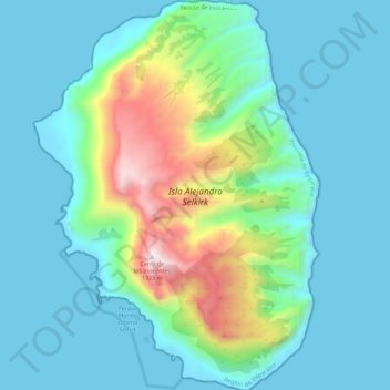
Isla Alejandro Selkirk topographic map
Interactive map
Click on the map to display elevation.
About this map
Name: Isla Alejandro Selkirk topographic map, elevation, terrain.
Average elevation: 265 m
Minimum elevation: -4 m
Maximum elevation: 1,352 m
Alejandro Selkirk has a subtropical climate, moderated by the cold Humboldt Current and the southeast trade winds. Temperatures range from 3 °C (37 °F) to 34 °C (93 °F), with an annual mean of 15.4 °C (59.7 °F). Higher elevations are generally cooler. Average annual precipitation is 1,081 mm (42.6 in), varying from 318 mm (12.5 in) to 1,698 mm (66.9 in) year to year. Rainfall is higher in the winter months, and varies with elevation and exposure; elevations above 500 m (1,640 ft) experience almost daily rainfall.
Other topographic maps
Click on a map to view its topography, its elevation and its terrain.
Robinson Crusoe Island
Chile > Valparaiso Region > Juan Fernández
Robinson Crusoe Island, Juan Fernández, Provincia de Valparaíso, Valparaiso Region, Chile
Average elevation: 44 m