
Swanston topographic map
Interactive map
Click on the map to display elevation.
Swanston
The area was traditionally seen as two farm estates: Easter Swanston owned by the Ross family; and Wester Swanston owned by the Foulis family. The two were united in 1749 when the Trotters of Mortonhall (who had bought Wester Swanston in 1670) also acquired Easter Swanston. The Trotter family planted the T-Wood to the south of the village. This is actually cruciform in plan, but due to local topography appears as a T (for Trotter) from the four compass points. It memorialises a family member lost in battle.
About this map
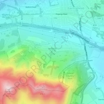
Name: Swanston topographic map, elevation, terrain.
Location: Swanston, City of Edinburgh, Scotland, United Kingdom (55.88885 -3.22248 55.89567 -3.21329)
Average elevation: 232 m
Minimum elevation: 130 m
Maximum elevation: 490 m
Scotland trails, hiking, mountain biking, running and outdoor activities