
Tinian Island topographic map
Interactive map
Click on the map to display elevation.
Tinian Island
Tinian is about 5 nautical miles (9.3 km) southwest of Saipan, from which it is separated by the Saipan Channel. It has a land area of 39 square miles (100 km2), with its highest elevation on the Kastiyu plateau at 187 meters (614 ft). It is considerably flatter than Saipan. The island has limestone cliffs and caves. There is a variety of marine life and coral reefs surrounding the island. Its clear, warm waters are ideal for snorkeling, scuba diving, and sport fishing.
About this map
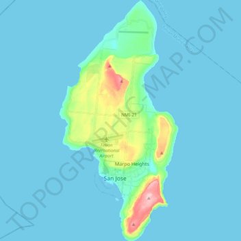
Name: Tinian Island topographic map, elevation, terrain.
Average elevation: 17 m
Minimum elevation: 0 m
Maximum elevation: 187 m