
Aldabra topographic map
Interactive map
Click on the map to display elevation.
About this map
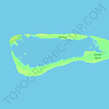
Name: Aldabra topographic map, elevation, terrain.
Location: Aldabra, Seychelles (-9.49597 46.19928 -9.36356 46.52580)
Average elevation: 1 m
Minimum elevation: -1 m
Maximum elevation: 14 m
In the early 1800s, concessions given to individuals almost destroyed the forests and tortoise habitats in many islands in Seychelles; on Aldabra Atoll, in view of its remoteness and rugged topography, only small areas of forests were cleared for agricultural operations (mostly coconut plantations) but the tortoises were intensely captured for meat and trade. However, James Spurs, who had the concession of the atoll, was responsible initially for saving the tortoises on the atoll when he banned killing them in 1891.
Other topographic maps
Click on a map to view its topography, its elevation and its terrain.
Praslin
Seychelles > Praslin group > Baie Saint Anne District > Baie Sainte Anne
Praslin, Baie Sainte Anne, Baie Saint Anne District, Praslin group, Seychelles
Average elevation: 25 m
Romainville Island
Romainville Island, Victoria, Seychelles
Average elevation: 2 m
Anse Nord D'Est
Anse Nord D'Est, North Coast Road, Ma Constance, Mahé, SEZ, Seychelles
Average elevation: 41 m