
Pezinok topographic map
Interactive map
Click on the map to display elevation.
About this map
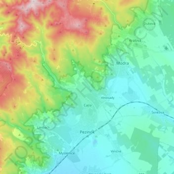
Name: Pezinok topographic map, elevation, terrain.
Location: Pezinok, District of Pezinok, Region of Bratislava, Slovakia (48.25495 17.15309 48.38155 17.31548)
Average elevation: 300 m
Minimum elevation: 129 m
Maximum elevation: 748 m
Pezinok lies at an altitude of 152 metres (499 ft) above sea level and covers an area of 72.555 square kilometres (28.0 sq mi).[6] It is located in the Danubian Lowland at the foothills of the Little Carpathians, around 20 km (12.43 mi) north-east of Bratislava. Another major city, Trnava, is located around 25 km (15.53 mi) to the east.
Other topographic maps
Click on a map to view its topography, its elevation and its terrain.
Vištuk
Slovakia > Region of Bratislava > District of Pezinok
Vištuk, District of Pezinok, Region of Bratislava, 900 85, Slovakia
Average elevation: 185 m
Častá
Slovakia > Region of Bratislava > District of Pezinok
Častá, District of Pezinok, Region of Bratislava, 900 89, Slovakia
Average elevation: 262 m
Štefanová
Slovakia > Region of Bratislava > District of Pezinok
Štefanová, District of Pezinok, Region of Bratislava, Slovakia
Average elevation: 210 m