
Ben Tre Province topographic map
Interactive map
Click on the map to display elevation.
About this map
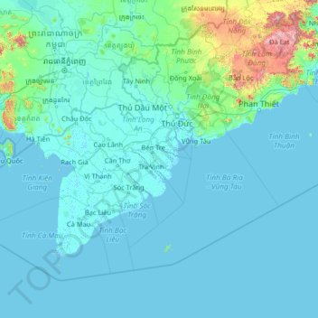
Name: Ben Tre Province topographic map, elevation, terrain.
Location: Ben Tre Province, Vietnam (7.52453 103.86904 12.72453 109.06904)
Average elevation: 88 m
Minimum elevation: -3 m
Maximum elevation: 2,346 m
Other topographic maps
Click on a map to view its topography, its elevation and its terrain.
Ho Chi Minh City
Ho Chi Minh City is located in the south-eastern region of Vietnam, 1,760 km (1,090 mi) south of Hanoi. The average elevation is 5 m (16 ft) above sea level for the city centre and 16 m (52 ft) for the suburb areas. It borders Tây Ninh Province and Bình Dương Province to the north, Đồng Nai Province and…
Average elevation: 17 m
Ho Chi Minh City
The city is located in the south-eastern region of Vietnam, 1,760 km (1,090 mi) south of Hanoi. The average elevation is 5 m (16 ft) above sea level for the city centre and 16 m (52 ft) for the suburb areas. It borders Tây Ninh Province and Bình Dương Province to the north, Đồng Nai Province and Bà…
Average elevation: 26 m
Ho Chi Minh City
Ho Chi Minh City is located in the south-eastern region of Vietnam, 1,760 km (1,090 mi) south of Hanoi. The average elevation is 5 m (16 ft) above sea level for the city centre and 16 m (52 ft) for the suburb areas.[53] It borders Tây Ninh Province and Bình Dương Province to the north, Đồng Nai Province…
Average elevation: 17 m
Sa Pa
Vietnam > Lao Cai province > Xã Tả Van
Sa Pa District is in Lào Cai Province, northwest Vietnam, 380 km northwest of Hanoi close to the border with China. The Hoàng Liên Sơn range of mountains dominates the district, which is at the eastern extremity of the Himalayas. This range includes Vietnam's highest mountain, Fan Si Pan, at a height of…
Average elevation: 1,270 m
Công Viên Trường Đại Học Phú Yên
Vietnam > Đắk Lắk province > Phường Tuy Hòa > Tuy Hòa
Average elevation: 6 m
Tây Ninh Province
Tây Ninh has a tropical monsoon climate with two distinct seasons: a dry season from December to April and a rainy season from May to November. The temperature remains fairly consistent, with cooler and drier conditions in the early dry season and warmer, more humid weather in the rainy season. Daytime…
Average elevation: 21 m
Gia Lai Province
Gia Lai is a mountainous province located in the northern Central Highlands at an average altitude of 700 - 800 m above sea level with an area of Convert 15510.13 km2, an average population of 1,590,980 people (2022). Gia Lai borders Kon Tum Province to the north, Dak Lak Province to the south, Cambodia to the…
Average elevation: 366 m
Bến Tre
Vietnam > Vinh Long province > Phường An Hội > Bến Tre
The city has a relatively flat terrain with a dense system of canals, an average elevation of 1-1.5m above sea level; it is an alluvial land on low ground surrounded by the Hàm Luông River to the West, Bến Tre River to the South, and Chẹt Sậy Canal to the East. In the inner city area, there are Cái…
Average elevation: 3 m
Lâm Đồng Province
The three highest plateaus of the Central Highlands: Lâm Viên, Di Linh, and Bảo Lộc (formerly known as B'Lao), are located in Lâm Đồng province at an elevation of 1,500 meters above sea level. The provincial capital, Đà Lạt City, is situated 300 km northeast of Ho Chi Minh City, 658 km south of…
Average elevation: 181 m
Mai Châu District
Vietnam > Phu Tho Province > Mai Châu Commune
According to the topographic characteristics, Mai Châu can be divided into two distinct areas : the low region (relatively flat terrain with fertile soil) and the high region (with many high and rugged mountain ranges).
Average elevation: 549 m
Yersin Park
Vietnam > Lâm Đồng Province > Phường Xuân Hương - Đà Lạt > Da Lat
Average elevation: 1,482 m
Hưng Yên Province
Hưng Yên has the features of a delta province : Flat topography without hills and mountains. There are 61,037 hectares of agricultural land, of which 55,645 hectares (91%) are for yearly cultivation and the remainder are for cultivation of perennial plants, fish farming, specialized cultivation and other…
Average elevation: 11 m
Thái Nguyên Province
The Tam Đảo mountain region is protected by the Tam Đảo National Park, established in 1996, which is one of the largest national parks in the country. There are over 20 peaks with the park area, others of note include Thien Thi at 1,375 m, Thach Ban at 1,388 m and Phu Nghia at 1,300 m. Sharp peaks with…
Average elevation: 323 m