
Baie-Comeau topographic map
Interactive map
Click on the map to display elevation.
About this map
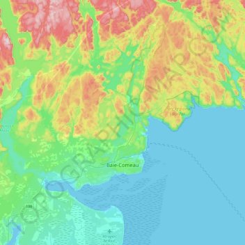
Name: Baie-Comeau topographic map, elevation, terrain.
Location: Baie-Comeau, Manicouagan, Côte-Nord, Quebec, Canada (49.17954 -68.50306 49.34707 -68.04533)
Average elevation: 104 m
Minimum elevation: -1 m
Maximum elevation: 409 m
Other topographic maps
Click on a map to view its topography, its elevation and its terrain.
Mont Veyrier
Canada > Quebec > Manicouagan > Rivière-aux-Outardes
Mont Veyrier, Rivière-aux-Outardes, Manicouagan, Côte-Nord, Quebec, Canada
Average elevation: 985 m