
Dakshina Kannada topographic map
Interactive map
Click on the map to display elevation.
Dakshina Kannada
The topography of the district is plain up to 30 km (18.64 mi) inside the coast and changes to undulating hilly terrain sharply towards the east in the Western Ghats. Teak, bamboo and rosewood trees are found in the hilly areas towards the east. The Geological Survey of India has identified this district as a moderately earthquake-prone region and categorised it in the Seismic III Zone. In rural Dakshina Kannada, houses are in the midst of a farm field or plantations of coconut or arecanut, separated by a few hundred metres.
About this map
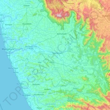
Name: Dakshina Kannada topographic map, elevation, terrain.
Location: Dakshina Kannada, Karnataka, India (12.46009 74.77687 13.18516 75.67064)
Average elevation: 257 m
Minimum elevation: -2 m
Maximum elevation: 1,866 m
Other topographic maps
Click on a map to view its topography, its elevation and its terrain.
Mysuru
India > Karnataka > Mysuru taluk
Mysore (/maɪˈsɔːr/ (listen)), officially Mysuru ([ˈmaɪˈsuːɾu] (listen)), is a city in the southern part of the state of Karnataka, India. Mysore city is geographically located between 12° 18′ 26″ north latitude and 76° 38′ 59″ east longitude. It is located at an altitude of 770 m (2,530 ft)…
Average elevation: 727 m
Mangaluru
India > Karnataka > Mangaluru taluk
Mangalore is also the administrative headquarters of the Dakshina Kannada district; it is a commercial, industrial, educational, healthcare, and startup hub. The city's international airport is the second-largest and second-busiest airport in Karnataka. Mangalore City Corporation is responsible for the civic…
Average elevation: 25 m
Udupi
India > Karnataka > Udupi taluku
Udupi has an elevation of 27 m (89 ft) above mean sea level. The climate in Udupi is hot in summers and pleasant in winter. During summers (from March to May) the temperature reaches up to 38 °C (100 °F) and in winters (from December to February) it is usually between 32 and 20 °C (90 and 68 °F). As it is…
Average elevation: 17 m
Vijayapura
India > Karnataka > Devanahalli taluku
Vijayapura is located at 13°17′N 77°48′E / 13.29°N 77.8°E / 13.29; 77.8. It has an average elevation of 883 metres (2896 feet).
Average elevation: 887 m
Bagalkote
India > Karnataka > Bagalakote taluk
Bagalkote, is a city in the state of Karnataka, India, which is also the headquarters of Bagalkot district. It is situated on branch of River Ghataprabha, The population of the urban agglomeration was 111,933 according to the provisional results of 2011 national census of India, the city is spread over an area…
Average elevation: 556 m
Srinivaspur
India > Karnataka > Srinivasapura taluku
Srinivaspur is located at 13°20′N 78°13′E / 13.33°N 78.22°E / 13.33; 78.22. It has an average elevation of 819 metres (2,687 ft). The geographical area of the taluk is 860 square kilometres (330 sq mi).
Average elevation: 830 m
Raichur
India > Karnataka > Rayachuru taluku
Raichur is located at 16°12′N 77°22′E / 16.2°N 77.37°E / 16.2; 77.37 on Deccan plateau. It has an average elevation of 407 metres (1335 ft)
Average elevation: 378 m
Kampli
India > Karnataka > Kampli taluk
Kampli is located at: 15°24′N 76°37′E / 15.4°N 76.62°E / 15.4; 76.62. It has an average elevation of 414 metres (1358 feet).
Average elevation: 403 m
Chincholi
India > Karnataka > Chincholi taluku
Chincholi is located at 17°28′N 77°26′E / 17.47°N 77.43°E / 17.47; 77.43. It has an average elevation of 462 m (1,516 ft). The town is spread over an area of 6 km2 (2.3 sq mi).
Average elevation: 466 m
Sira
India > Karnataka > Sira taluk
Sira is located at 13°45′N 76°55′E / 13.75°N 76.91°E / 13.75; 76.91. It has an average elevation of 662 metres (2171 feet).
Average elevation: 655 m
Karkala
India > Karnataka > Karkala taluk
Karla is located at 13°12′N 74°59′E / 13.2°N 74.98°E / 13.2; 74.98. It has an average elevation of 81 metres (265 feet).
Average elevation: 80 m
Mysuru
India > Karnataka > Mysuru taluk
Mysore (/maɪˈsɔːr/ (listen)), officially Mysuru ([ˈmaɪˈsuːɾu] (listen)), is a city in the southern part of the state of Karnataka, India. Mysore city is geographically located between 12° 18′ 26″ north latitude and 76° 38′ 59″ east longitude. It is located at an altitude of 770 m (2,530 ft)…
Average elevation: 727 m
Kampli
India > Karnataka > Kampli taluk
Kampli is located at: 15°24′N 76°37′E / 15.4°N 76.62°E / 15.4; 76.62. It has an average elevation of 414 metres (1358 feet).
Average elevation: 403 m
Krishnarajanagara
India > Karnataka > Krishnarajanagara taluk
Krishnarajanagara is located on the northern part of Mysore district, west of the Krishna Raja Sagara Reservoir. It has an average elevation of 786 metres above sea level. NH-373, also known as SH-57 passes through the town of K.R.Nagara.
Average elevation: 786 m
Yelanduru
India > Karnataka > Yalanduru taluk
Yelandur is located at 12°04′N 77°02′E / 12.07°N 77.03°E / 12.07; 77.03. It has an average elevation of 555 metres (1820 feet). Yalandur is the taluk and city in Chamarajanagar district in Karnataka state of India. It consists of 33 villages. It is situated about 59 km south-west of Mysuru and…
Average elevation: 660 m
Kalaburagi
India > Karnataka > Kalaburagi taluku
The entire district is on the Deccan Plateau, and the elevation ranges from 300 to 750 m above MSL. Two main rivers, the Krishna and Bhima, flow through the district. The predominant soil type is black soil. The district has many tanks, which irrigate the land along with the river. The Upper Krishna Project is…
Average elevation: 465 m
Chintamani
India > Karnataka > Chintamani taluk
Chintamani lies in the southeast of the South Indian state of Karnataka. It is in the heart of the Mysore Plateau at an average elevation of 865 m (2,838 ft). The Taluk geographically lies between 78°12′36″N 13°16′38″E / 78.21000°N 13.27722°E / 78.21000; 13.27722 and 77°51′39″N…
Average elevation: 886 m
Channagiri
India > Karnataka > Channagiri taluku
Channagiri is located at 14°02′N 75°56′E / 14.03°N 75.93°E / 14.03; 75.93. It has an average elevation of 662 metres (2171 feet).
Average elevation: 679 m
Bengaluru
India > Karnataka > Bangalore North
Bengaluru lies in the southeast of the South Indian state of Karnataka in the heart of the Mysore Plateau (a region of the larger Deccan Plateau) at an average elevation of 900 m (2,953 ft). The city covers an area of 741 km2 (286 sq mi). The Bengaluru metropolitan region covers an area of 7,005 km2 (2,705 sq…
Average elevation: 879 m