
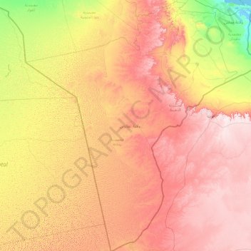
Tataouine topographic map
Interactive map
Click on the map to display elevation.
About this map
Name: Tataouine topographic map, elevation, terrain.
Location: Tataouine, Tunisia (30.22906 8.35683 33.23475 11.34198)
Average elevation: 295 m
Minimum elevation: -3 m
Maximum elevation: 714 m
Wells from aquifers dot the eastern slopes of the pronounced long escarpment climbing gradually from 100 m to 500 m in elevation two provinces north in the south extreme of Gabes Governorate, passing through a thin strip of Medenine and then at the heart of the province ending around a capital city Tripoli, Libya. The ridge attracts variable winter and early spring relief precipitation and little other rain and shares with the rest of the area a hot desert climate (Köppen climate classification BWh) with long, extremely hot summers throughout (see North-south graduation of Tunisian climatic zones), the patchy and infrequent rainfall in winter is greater than the average for the Sahara Desert of which the area forms part. Approximately half of the escarpment exceeds 500 m in the province, the peak within Tunisia being 631 m near the town of Remada on the main road south of Tatouine leading into mid-eastern Libya. The tripoint of the three countries is close to the Libyan town of Ghadames which has surrounding it three airstrips, one of which constitutes an airport and one of which lies in Algeria. Close to the west or south-west border is El Borma Airport and the province has a second, which is for defence and rescue, Remada Air Base.
Other topographic maps
Click on a map to view its topography, its elevation and its terrain.
Menzel Bouzaiane
Tunisia > Sidi Bouzid > منزل بوزيان
Menzel Bouzaiane, منزل بوزيان, معتمدية منزل بوزيان, Sidi Bouzid, 9114, Tunisia
Average elevation: 315 m
El Founi
Tunisia > Sidi Bouzid > الفوني
El Founi, الفوني, معتمدية المزونة, Sidi Bouzid, Tunisia
Average elevation: 75 m
السعيدة الشرقية
السعيدة الشرقية, الرقاب, Sidi Bouzid, Tunisia
Average elevation: 137 m
الخشم الشرقية
الخشم الشرقية, الرقاب, Sidi Bouzid, Tunisia
Average elevation: 151 m
الخرشف
الخرشف, معتمدية منزل بوزيان, Sidi Bouzid, Tunisia
Average elevation: 282 m
بنور
بنور, معتمدية سيدي بوزيد الشرقية, Sidi Bouzid, Tunisia
Average elevation: 344 m
عين رباو
عين رباو, معتمدية سيدي بوزيد الشرقية, Sidi Bouzid, Tunisia
Average elevation: 326 m
Sidi Ali Ben Aoun
Tunisia > Sidi Bouzid > سيدي علي بن عون
Sidi Ali Ben Aoun, سيدي علي بن عون, معتمدية سيدي علي بن عون, Sidi Bouzid, Tunisia
Average elevation: 461 m
Sidi Salah
Sidi Salah, سيدي صالح, معتمدية ساقية الزيت, Sfax, 3091, Tunisia
Average elevation: 53 m
Chenini
Tunisia > Tataouine > شنني الجديدة
Chenini, شنني الجديدة, معتمدية تطاوين الجنوبية, Tataouine, 3222, Tunisia
Average elevation: 428 m
Sousse
Tunisia > Sousse > الهادي شاكر
Sousse, الهادي شاكر, معتمدية سوسة جوهرة, Sousse, Tunisia, سوسة
Average elevation: 24 m
أريانة العليا
أريانة العليا, معتمدية أريانة المدينة, Ariana, 2037, Tunisia
Average elevation: 66 m
Redeyef
Tunisia > Gafsa > الرديف المحطة
Redeyef, الرديف المحطة, معتمدية الرديف, Gafsa, Tunisia
Average elevation: 585 m
أم العرائس المركزية
أم العرائس المركزية, معتمدية أم العرائس, Gafsa, Tunisia
Average elevation: 565 m
قصور الساف الرياض
قصور الساف الرياض, معتمدية قصور الساف, Mahdia, Tunisia
Average elevation: 18 m
New Zraoua
New Zraoua, الزراوة, معتمدية مطماطة الجديدة, Gabès, 6024, Tunisia
Average elevation: 154 m
Medina of Tunis
Medina of Tunis, الأسواق, معتمدية المدينة, Tunis, Tunisia
Average elevation: 16 m
معتمدية سيدي بوزيد الشرقية
معتمدية سيدي بوزيد الشرقية, Sidi Bouzid, 9141, Tunisia
Average elevation: 333 m
Kelibia
Tunisia > Nabeul > قليبية الغربية
Kelibia, قليبية الغربية, معتمدية قليبية, Nabeul, 8090, Tunisia
Average elevation: 18 m
بئر ثلاثين
Tunisia > Tataouine > بئر الثلاثين > بئر ثلاثين
بئر ثلاثين, بئر الثلاثين, معتمدية تطاوين الجنوبية, Tataouine, 3284, Tunisia
Average elevation: 313 m