Geolocate

Bỉm Sơn topographic map

Interactive map

Click on the map to display elevation.

About this map

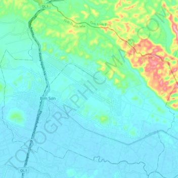
Name: Bỉm Sơn topographic map, elevation, terrain.

Location: Bỉm Sơn, Thanh Hoa, Vietnam (20.04412 105.83313 20.13228 105.92979)

Average elevation: 40 m

Minimum elevation: -3 m

Maximum elevation: 225 m

Other topographic maps

Click on a map to view its topography, its elevation and its terrain.

Đồng Ma

Vietnam > Thanh Hoa > Đồng Ma

Đồng Ma, Như Thanh District, Thanh Hoa, Vietnam

Average elevation: 37 m

Đồng Lam

Vietnam > Thanh Hoa > Đồng Lam

Đồng Lam, Như Thanh District, Thanh Hoa, Vietnam

Average elevation: 97 m

Nghi Sơn Town

Vietnam > Thanh Hoa > Nghi Sơn Town

Nghi Sơn Town, Thanh Hoa, Vietnam

Average elevation: 33 m

Nông Cống

Vietnam > Thanh Hoa > Nông Cống

Nông Cống, Nông Cống District, Thanh Hoa, Vietnam

Average elevation: 7 m

Quán Lào

Vietnam > Thanh Hoa > Quán Lào

Quán Lào, Yên Định District, Thanh Hoa, 440000, Vietnam

Average elevation: 11 m

Thọ Xuân

Vietnam > Thanh Hoa > Thọ Xuân

Thọ Xuân, Thọ Xuân District, Thanh Hoa, Vietnam

Average elevation: 13 m