
Make a donation
Gear up for your next adventure:
As an Amazon Associate, this site earns from qualifying purchases at no extra cost to you.
Cody topographic map
Click on the map to display elevation.
Make a donation
Gear up for your next adventure:
As an Amazon Associate, this site earns from qualifying purchases at no extra cost to you.
Cody
Cody's elevation is approximately 4,997 feet (1,523 m) above sea level. The main part of the city is split across three levels, separated by about 60 feet (18 m).
Make a donation
Gear up for your next adventure:
As an Amazon Associate, this site earns from qualifying purchases at no extra cost to you.
About this map
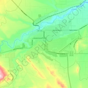
Name: Cody topographic map, elevation, terrain.
Location: Cody, Park County, Wyoming, United States (44.48981 -109.12048 44.55131 -109.00576)
Average elevation: 1,557 m
Minimum elevation: 1,436 m
Maximum elevation: 1,798 m
Make a donation
Gear up for your next adventure:
As an Amazon Associate, this site earns from qualifying purchases at no extra cost to you.
Other topographic maps
Click on a map to view its topography, its elevation and its terrain.
Make a donation
Gear up for your next adventure:
As an Amazon Associate, this site earns from qualifying purchases at no extra cost to you.
Druid Peak
United States > Wyoming > Park County
Druid Peak (elevation 9,577 feet (2,919 m)) is a moderate domed peak on the southern flank of the Absaroka Range in Yellowstone National Park. The peak lies just north of the Lamar River and Soda Butte Creek confluence at the head of the Lamar Valley. Prior to 1885, this summit was named Soda Hill by members…
Average elevation: 2,597 m
Make a donation
Gear up for your next adventure:
As an Amazon Associate, this site earns from qualifying purchases at no extra cost to you.
Make a donation
Gear up for your next adventure:
As an Amazon Associate, this site earns from qualifying purchases at no extra cost to you.