
Sevastopol topographic map
Interactive map
Click on the map to display elevation.
About this map
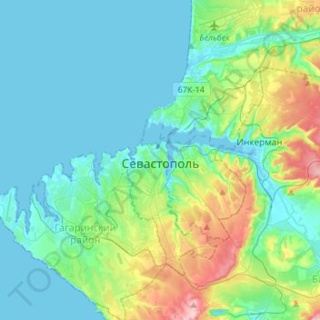
Name: Sevastopol topographic map, elevation, terrain.
Location: Sevastopol, Southern Federal District, 99001, Russia (44.51225 33.37796 44.70140 33.61062)
Average elevation: 58 m
Minimum elevation: -2 m
Maximum elevation: 288 m
Other topographic maps
Click on a map to view its topography, its elevation and its terrain.
Crimean Peninsula
Crimean Peninsula, Sevastopol, Southern Federal District, Russia
Average elevation: 35 m