
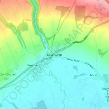
East Ayton topographic map
Interactive map
Click on the map to display elevation.
About this map
Name: East Ayton topographic map, elevation, terrain.
Average elevation: 66 m
Minimum elevation: 23 m
Maximum elevation: 167 m
Other topographic maps
Click on a map to view its topography, its elevation and its terrain.
Aislaby
United Kingdom > England > North Yorkshire > Scarborough
Aislaby, Scarborough, North Yorkshire, England, YO21 1SN, United Kingdom
Average elevation: 104 m
Roxby
United Kingdom > England > North Yorkshire > Scarborough
Roxby, Scarborough, North Yorkshire, England, TS13 5EE, United Kingdom
Average elevation: 128 m
Snainton
United Kingdom > England > North Yorkshire > Scarborough
Snainton, Scarborough, North Yorkshire, England, United Kingdom
Average elevation: 50 m
Sawdon
United Kingdom > England > North Yorkshire > Scarborough
Sawdon, Scarborough, North Yorkshire, England, YO13 9DX, United Kingdom
Average elevation: 118 m
Ugthorpe
United Kingdom > England > North Yorkshire > Scarborough
Ugthorpe, Scarborough, North Yorkshire, England, United Kingdom
Average elevation: 180 m
Cayton Bay
United Kingdom > England > North Yorkshire > Scarborough > Osgodby
Cayton Bay, Osgodby, Scarborough, North Yorkshire, England, United Kingdom
Average elevation: 35 m
High Seat
United Kingdom > England > North Yorkshire > Scarborough
High Seat, Scarborough, North Yorkshire, England, YO13 0LB, United Kingdom
Average elevation: 139 m
Castleton
United Kingdom > England > North Yorkshire > Scarborough
Castleton, Scarborough, North Yorkshire, England, YO21 2EF, United Kingdom
Average elevation: 187 m
Hayburn Wyke
United Kingdom > England > North Yorkshire > Scarborough
Hayburn Wyke, Scarborough, North Yorkshire, Yorkshire and the Humber, England, YO13 0HA, United Kingdom
Average elevation: 65 m
Oat Mill Hill
United Kingdom > England > North Yorkshire > Scarborough > Lealholm
Oat Mill Hill, Glaisdale, Lealholm, Scarborough, North Yorkshire, England, YO21 2AQ, United Kingdom
Average elevation: 168 m
Harwood Dale
United Kingdom > England > North Yorkshire > Scarborough > Harwood Dale
Harwood Dale, Scarborough, North Yorkshire, Yorkshire and the Humber, England, United Kingdom
Average elevation: 160 m
Sawdon
United Kingdom > England > North Yorkshire > Scarborough > Sawdon
Sawdon, Scarborough, North Yorkshire, Yorkshire and the Humber, England, YO13 9DX, United Kingdom
Average elevation: 119 m
Goathland
United Kingdom > England > North Yorkshire > Scarborough
Goathland, Scarborough, North Yorkshire, England, United Kingdom
Average elevation: 204 m
Broxa
United Kingdom > England > North Yorkshire > Scarborough > Broxa
Broxa, Scarborough, North Yorkshire, Yorkshire and the Humber, England, YO13 0BP, United Kingdom
Average elevation: 126 m
Scarborough Castle
United Kingdom > England > North Yorkshire > Scarborough
Scarborough Castle, Longwestgate, The Old Town, Scarborough, North Yorkshire, Yorkshire and the Humber, England, YO11 1RG, United Kingdom
Average elevation: 9 m
Lebberston
United Kingdom > England > North Yorkshire > Scarborough
Lebberston, Scarborough, North Yorkshire, England, United Kingdom
Average elevation: 36 m
Ravenscar
United Kingdom > England > North Yorkshire > Scarborough > Ravenscar
Ravenscar, Scarborough, North Yorkshire, Yorkshire and the Humber, England, YO13 0NY, United Kingdom
Average elevation: 117 m