
Rivière de Beauvallon topographic map
Interactive map
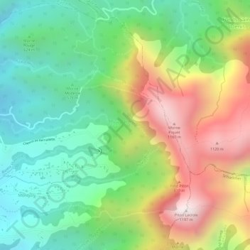
Click on the map to display elevation.
About this map
Name: Rivière de Beauvallon topographic map, elevation, terrain.
Average elevation: 674 m
Minimum elevation: 328 m
Maximum elevation: 1,164 m
Other topographic maps
Click on a map to view its topography, its elevation and its terrain.
Morne Rouge
France > Martinique > Le Morne-Vert
Morne Rouge, Le Morne-Vert, Saint-Pierre, Martinique, 97226, France
Average elevation: 444 m