
Paschendale topographic map
Interactive map
Click on the map to display elevation.
About this map
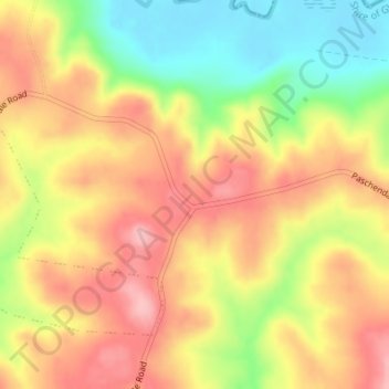
Name: Paschendale topographic map, elevation, terrain.
Location: Paschendale, Shire of Glenelg, Victoria, Australia (-37.66838 141.58373 -37.64838 141.60373)
Average elevation: 138 m
Minimum elevation: 60 m
Maximum elevation: 199 m
Other topographic maps
Click on a map to view its topography, its elevation and its terrain.
King Valley
The King Valley has a history that includes bushrangers, Chinese and Italian immigration. Chinese migrants came from the Victorian Goldfields in the mid-19th century and began careers as market gardeners, tobacco growers and merchants. Many roads in the Valley today carry the names of such families, like…
Average elevation: 295 m
Collingwood
Australia > Victoria > Melbourne
Collingwood's topography is mostly flat, but a prominent slope extends from Hoddle Street up to Smith Street, and also along sections of Hoddle Street.
Average elevation: 30 m