Geolocate

Guadeloupe topographic map

Interactive map

Click on the map to display elevation.

Guadeloupe

The two main islands are Basse-Terre (west) and Grande-Terre (east), which form a butterfly shape as viewed from above, the two 'wings' of which are separated by the Grand Cul-de-Sac Marin, Rivière Salée [fr] and Petit Cul-de-Sac Marin. More than half of Guadeloupe's land surface consists of the 847.8 km2 Basse-Terre. The island is mountainous, containing such peaks as Mount Sans Toucher (4,442 feet; 1,354 metres) and Grande Découverte (4,143 feet; 1,263 metres), culminating in the active volcano La Grande Soufrière, the highest mountain peak in the Lesser Antilles with an elevation of 1,467 metres (4,813 ft). In contrast Grande-Terre is mostly flat, with rocky coasts to the north, irregular hills at the centre, mangrove at the southwest, and white sand beaches sheltered by coral reefs along the southern shore. This is where the main tourist resorts are found.

Wikipedia (CC-BY-SA 3.0)

About this map

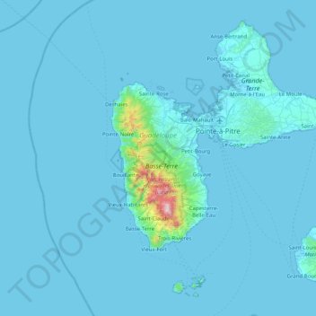
Name: Guadeloupe topographic map, elevation, terrain.

Location: Guadeloupe, France (15.83198 -61.80976 16.51448 -61.00130)

Average elevation: 37 m

Minimum elevation: -1 m

Maximum elevation: 1,442 m

Other topographic maps

Click on a map to view its topography, its elevation and its terrain.

Pyrenees

France > Occitania >

In the Western Pyrenees, from the Basque mountains near the Bay of Biscay of the Atlantic Ocean, the average elevation gradually increases from west to east.

Average elevation: 2,716 m

Os

France > New Aquitaine > Os

Average elevation: 105 m

Lidar

France > Auvergne-Rhône-Alpes > Cantal > Brezons

Average elevation: 1,048 m

Mont Blanc / Monte Bianco

France > Auvergne-Rhône-Alpes > Upper Savoy > Saint-Gervais-les-Bains

The climate is cold and temperate (Köppen climate classification Cfb), and is greatly influenced by altitude. Being the highest part of the Alps, Mont Blanc and surrounding mountains can create their own weather patterns. Temperatures drop as the mountains gain in height, and the summit of Mont Blanc is a…

Average elevation: 4,092 m

Hasting

France > Normandy > Calvados > Dives-sur-Mer

Average elevation: 32 m

Marlieu

France > Auvergne-Rhône-Alpes > Ain > Talissieu

Average elevation: 339 m

Col du Mont Cenis

France > Auvergne-Rhône-Alpes > Savoy > Val-Cenis

Average elevation: 2,241 m

Lac de Paladru

France > Auvergne-Rhône-Alpes > Isère > Paladru

The lake area has a cool temperate climate. The north–south orientation and relatively high altitude means the average temperature is around 10 °C. Rainfall is irregular, with most rain occurring in June and October with the rise of humid air masses from the Mediterranean. January is the coldest month, with…

Average elevation: 569 m

La Marelle

France > Normandy > Manche > Sacey

Average elevation: 46 m

Noyelles

France > Hauts-de-France > Pas-de-Calais > Bours

Average elevation: 125 m

Kutz

France > Grand Est > Haut-Rhin > Katzenthal

Average elevation: 351 m

Morne à Vaches

France > Guadeloupe > Basse-Terre

Average elevation: 117 m

Crique Paracou

France > French Guiana > Sinnamary

Average elevation: 5 m

Le Bez

France > Occitania > Tarn > Mirandol-Bourgnounac

Average elevation: 373 m

Le Montbabut

France > Nouvelle-Aquitaine > Creuse > Mérinchal

Average elevation: 697 m

Leth

France > Occitania > Aveyron > Florentin-la-Capelle

Average elevation: 490 m

La Grande Roche

France > Brittany > Côtes-d'Armor > Plumieux

Average elevation: 104 m

Sapin

France > Auvergne-Rhône-Alpes > Ain > Chaleins

Average elevation: 239 m

Richat

France > Grand Est > Ardennes > Fromelennes

Average elevation: 165 m

Potin

France > Nouvelle-Aquitaine > Gironde > Samonac

Average elevation: 52 m

Les Carroz

France > Auvergne-Rhône-Alpes > Upper Savoy

Average elevation: 1,073 m

La Trivalle

France > Occitania > Hérault > Mons

Average elevation: 297 m

Blanchard

France > Brittany > Côtes-d'Armor > Trédias

Average elevation: 86 m

Champage

France > Auvergne-Rhône-Alpes > Allier > Coutansouze

Average elevation: 550 m

La Goëlle

France > Hauts-de-France > Nord > Prisches

Average elevation: 180 m

L'Armenaudière

France > Pays de la Loire > Sarthe > Écommoy

Average elevation: 116 m

Le pas de vache

France > Grand Est > Meuse > Clermont-en-Argonne

Average elevation: 212 m

La Thibaudière

France > Pays de la Loire > Sarthe > Arçonnay

Average elevation: 158 m

La Vallée

France > Brittany > Ille-et-Vilaine > Vezin-le-Coquet

Average elevation: 44 m

Larronville

France > Hauts-de-France > Somme > Rue

Average elevation: 8 m

La Mouffetière

France > Pays de la Loire > Mayenne > La Pallu

Average elevation: 210 m

Val-Claret

France > Auvergne-Rhône-Alpes > Savoy > Tignes

Average elevation: 2,409 m

La Valette

France > Normandy > Manche > Bricquebec-en-Cotentin > Quettetot

Average elevation: 118 m

Saint-Mars

France > Grand Est > Haute-Marne > Louvemont

Average elevation: 152 m

Papillon

France > Brittany > Ille-et-Vilaine > Liffré

Average elevation: 77 m

Fry

France > Auvergne-Rhône-Alpes > Upper Savoy > Taninges

Average elevation: 1,247 m

Le Petit Ronceur

France > Normandy > Manche > Le Mesnil-Garnier

Average elevation: 137 m

Le Domaine

France > Normandy > Calvados > Basseneville

Average elevation: 8 m

Ruisseau Blanc

France > Réunion > Saint-Denis

Average elevation: 385 m

Forget

France > Pays de la Loire > Loire-Atlantique > Casson

Average elevation: 29 m

Vandon

France > Nouvelle-Aquitaine > Charente-Maritime > Chambon

Average elevation: 23 m

Mont Fortune

France > Saint Martin (France)

Average elevation: 11 m

Les Rousses

France > Auvergne-Rhône-Alpes > Ain > Leyment

Average elevation: 245 m

La Mauselaine

France > Grand Est > Vosges > Gérardmer

Average elevation: 859 m

Les Boules

France > Occitania > Lot > Bellefont-La Rauze

Average elevation: 276 m

Polynesia

France > French Polynesia

Average elevation: 1 m

Cantone

France > Corsica > Haute-Corse > Calvi

Average elevation: 47 m

Cordouan

France > Pays de la Loire > Mayenne > Saint-Loup-du-Gast

Average elevation: 124 m

Locoal

France > Brittany > Morbihan > Locoal-Mendon

Average elevation: 4 m

Les Carrières

France > Brittany > Finistère > Huelgoat

Average elevation: 212 m

La Schlucht

France > Grand Est > Vosges > Le Valtin

Average elevation: 1,039 m

Moidrey

France > Normandy > Manche

Average elevation: 14 m

Debas

France > Nouvelle-Aquitaine > Dordogne > Neuvic > La Côte

Average elevation: 106 m

Lérab Ling

France > Occitania > Hérault > Roqueredonde

Average elevation: 726 m

Mt Tearai

France > French Polynesia > Moorea-Maiao

Average elevation: 271 m

Lac Blanc

France > Grand Est > Haut-Rhin > Orbey

Lac Blanc is a lake in Haut-Rhin, France. At an elevation of 1055 m, its surface area is 0.29 km².

Average elevation: 1,111 m

Ruffiers

France > Nouvelle-Aquitaine > Creuse > Le Grand-Bourg

Average elevation: 400 m

Les Pas

France > Normandy > Manche

Average elevation: 21 m

Les Bordes

France > Nouvelle-Aquitaine > Vienne > Gouex

Average elevation: 108 m

Les Matrons

France > Auvergne-Rhône-Alpes > Ardèche > Ardoix

Average elevation: 336 m

Grand Champ

France > Auvergne-Rhône-Alpes > Isère > Venon

Average elevation: 488 m

Valens

France > Auvergne-Rhône-Alpes > Ardèche > Rompon

Average elevation: 236 m

Kerfourchec

France > Brittany > Morbihan > Plumelin

Average elevation: 98 m