
Mestia topographic map
Interactive map
Click on the map to display elevation.
About this map
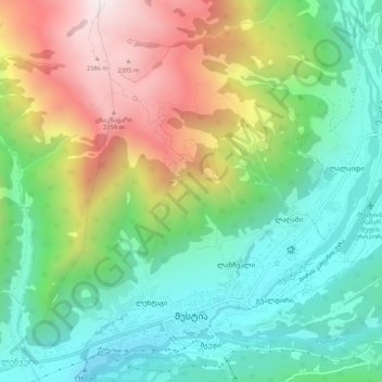
Name: Mestia topographic map, elevation, terrain.
Location: Mestia, Mestia Municipality, Samegrelo-Upper Svaneti, Georgia (43.03758 42.70463 43.07569 42.75821)
Average elevation: 1,749 m
Minimum elevation: 1,338 m
Maximum elevation: 2,461 m
Mestia (Georgian: მესტია IPA: [mɛstʼiɑ]) is a highland townlet (daba) in northwest Georgia, at an elevation of 1,500 metres (4,921 feet) in the Caucasus Mountains.
Other topographic maps
Click on a map to view its topography, its elevation and its terrain.
Adishi
Georgia > Samegrelo-Upper Svaneti > Mestia Municipality
Adishi, Mestia Municipality, Samegrelo-Upper Svaneti, Georgia
Average elevation: 4,123 m
Tetnuldi
Georgia > Samegrelo-Upper Svaneti > Mestia Municipality
Tetnuldi, Mestia Municipality, Samegrelo-Upper Svaneti, Georgia
Average elevation: 4,016 m
Nakra
Georgia > Samegrelo-Upper Svaneti > Mestia Municipality > Nakra
Nakra, Mestia Municipality, Samegrelo-Upper Svaneti, Georgia
Average elevation: 2,384 m
Ushguli
Georgia > Samegrelo-Upper Svaneti > Mestia Municipality
Ushguli, Mestia Municipality, Samegrelo-Upper Svaneti, Georgia
Average elevation: 4,129 m
Shkhara
Georgia > Samegrelo-Upper Svaneti > Mestia Municipality
Shkhara, Mestia Municipality, Samegrelo-Upper Svaneti, Georgia
Average elevation: 4,355 m