
Palopo topographic map
Interactive map
Click on the map to display elevation.
About this map
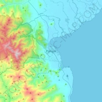
Name: Palopo topographic map, elevation, terrain.
Location: Palopo, South Sulawesi, 91921, Indonesia (-3.15963 120.03207 -2.83963 120.35207)
Average elevation: 298 m
Minimum elevation: 0 m
Maximum elevation: 1,895 m
Other topographic maps
Click on a map to view its topography, its elevation and its terrain.
Pontap
Indonesia > South Sulawesi > Palopo
Pontap, Palopo, South Sulawesi, 91921, Indonesia
Average elevation: 14 m