
Quảng Ninh District topographic map
Interactive map
Click on the map to display elevation.
About this map
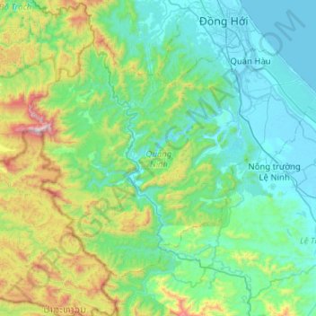
Name: Quảng Ninh District topographic map, elevation, terrain.
Location: Quảng Ninh District, Quang Binh province, Vietnam (17.07085 106.28730 17.43613 106.79671)
Average elevation: 308 m
Minimum elevation: -3 m
Maximum elevation: 1,597 m
Other topographic maps
Click on a map to view its topography, its elevation and its terrain.
Sơn Lý
Vietnam > Quang Binh province > Bố Trạch District
Sơn Lý, Bố Trạch District, Quang Binh province, Vietnam
Average elevation: 34 m
Phong Nha-Kẻ Bàng National Park
Phong Nha-Kẻ Bàng National Park, Quang Binh province, Vietnam
Average elevation: 424 m
Son Doong Cave
Vietnam > Quang Binh province > Bố Trạch
Son Doong Cave, West Ho Chi Minh Highway, Bố Trạch, Quang Binh province, Vietnam
Average elevation: 487 m
Lệ Thủy District
Lệ Thủy District, Quang Binh province, Vietnam
Average elevation: 171 m
Kiến Giang
Vietnam > Quang Binh province > Lệ Thủy District > Kiến Giang
Kiến Giang, Lệ Thủy District, Quang Binh province, Vietnam
Average elevation: 3 m
Bố Trạch District
Bố Trạch District, Quảng Bình Province, Vietnam
Average elevation: 356 m
Phong Nha Town
Vietnam > Quang Binh province > Bố Trạch District
Phong Nha Town, Bố Trạch District, Quảng Bình Province, Vietnam
Average elevation: 66 m