
Cusco topographic map
Interactive map
Click on the map to display elevation.
About this map
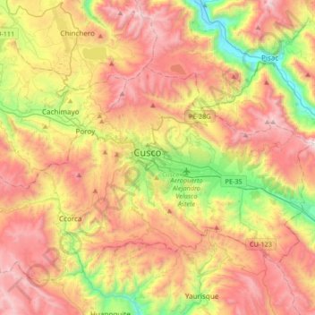
Name: Cusco topographic map, elevation, terrain.
Location: Cusco, 008400, Peru (-13.68284 -72.12763 -13.36284 -71.80763)
Average elevation: 3,788 m
Minimum elevation: 2,931 m
Maximum elevation: 4,649 m
Cusco (Spanish: Cuzco, Cusco ; Quechua: Qusqu, Qosqo , ), often spelled Cuzco, is a city in southeastern Peru, near the Urubamba Valley of the Andes mountain range. It is the capital of the Cusco Region and of the Cusco Province. In 2017, the city had a population of 428,450. Located on the eastern end of the Knot of Cuzco, its elevation is around 3,400 m (11,200 ft).
Other topographic maps
Click on a map to view its topography, its elevation and its terrain.
Mollococha
Mollococha, Cusco, Distrito de Cusco, Province of Cusco, Cusco, 08001, Peru
Average elevation: 3,585 m
City of Cuzco
City of Cuzco, Cusco, Distrito de Cusco, Province of Cusco, Cusco, 08001, Peru
Average elevation: 3,453 m