
Tanggerang topographic map
Interactive map
Click on the map to display elevation.
About this map
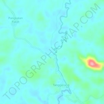
Name: Tanggerang topographic map, elevation, terrain.
Location: Tanggerang, Jelai Hulu, Ketapang, West Kalimantan, Indonesia (-2.00858 110.73279 -1.96858 110.77279)
Average elevation: 51 m
Minimum elevation: 29 m
Maximum elevation: 173 m
Other topographic maps
Click on a map to view its topography, its elevation and its terrain.
Air Upas
Indonesia > West Kalimantan > Ketapang
Air Upas, Ketapang, West Kalimantan, Indonesia
Average elevation: 36 m
Sekucing Labai
Indonesia > West Kalimantan > Ketapang
Sekucing Labai, Simpang Hulu, Ketapang, West Kalimantan, Indonesia
Average elevation: 10 m