
Coshquin topographic map
Interactive map
Click on the map to display elevation.
About this map
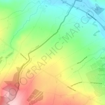
Name: Coshquin topographic map, elevation, terrain.
Average elevation: 91 m
Minimum elevation: 3 m
Maximum elevation: 207 m
Other topographic maps
Click on a map to view its topography, its elevation and its terrain.
Altnagelvin
United Kingdom > Northern Ireland > Londonderry/Derry
Altnagelvin, Londonderry/Derry, County Londonderry, Northern Ireland, United Kingdom
Average elevation: 67 m
Clooney
United Kingdom > Northern Ireland > Londonderry/Derry
Clooney, Londonderry/Derry, County Londonderry, Northern Ireland, United Kingdom
Average elevation: 39 m
Gransha
United Kingdom > Northern Ireland > Londonderry/Derry
Gransha, Londonderry/Derry, County Londonderry, Northern Ireland, BT47 6TG, United Kingdom
Average elevation: 22 m
Glack
United Kingdom > Northern Ireland > Londonderry/Derry
Glack, Londonderry/Derry, County Londonderry, Northern Ireland, United Kingdom
Average elevation: 201 m
Binevenagh
United Kingdom > Northern Ireland > Londonderry/Derry
Binevenagh, Londonderry/Derry, County Londonderry, Northern Ireland, BT49 0JB, United Kingdom
Average elevation: 246 m