
Sidi Khouiled topographic map
Interactive map
Click on the map to display elevation.
About this map
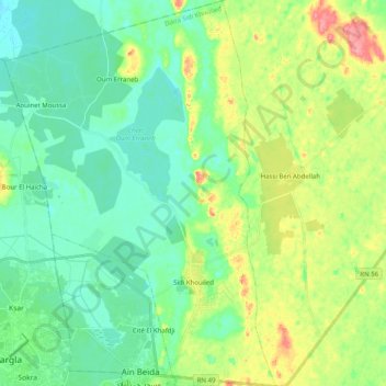
Name: Sidi Khouiled topographic map, elevation, terrain.
Location: Sidi Khouiled, Sidi Khouiled District, Ouargla, 30035, Algeria (31.93288 5.32108 32.10246 5.46148)
Average elevation: 142 m
Minimum elevation: 119 m
Maximum elevation: 194 m
Sidi Khouiled lies at an elevation of 159 metres (522 ft) above sea level, 9 kilometres (5.6 mi) from the provincial capital Ouargla. The land in the area alternates between sand dunes and flat rocky plains with small areas of fertile oases. Sidi Khouiled is encircled by small palm plantations built upon these oases.