
Юганская Обь topographic map
Interactive map
Click on the map to display elevation.
About this map
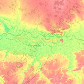
Name: Юганская Обь topographic map, elevation, terrain.
Average elevation: 49 m
Minimum elevation: 20 m
Maximum elevation: 96 m
Other topographic maps
Click on a map to view its topography, its elevation and its terrain.
Ural Mountains
Russia > Khanty-Mansiysk Autonomous Okrug – Ugra > Beryozovsky District
The Ural Mountains (/ˈjʊərəl/ YOOR-əl; Russian: Ура́льские го́ры, tr. Uralskiye gory, IPA: [ʊˈralʲskʲɪjə ˈɡorɨ]; Bashkir: Урал тауҙары) or simply the Urals, are a mountain range in Eurasia that runs north-south mostly through Russia, from the coast of the Arctic Ocean to…
Average elevation: 1,435 m
Пырьях
Russia > Khanty-Mansiysk Autonomous Okrug – Ugra > Khanty-Mansiysky District
Average elevation: 29 m
Chemashi
Russia > Khanty-Mansiysk Autonomous Okrug – Ugra > Oktyabrsky District
Average elevation: 25 m
Сосновка
Russia > Khanty-Mansiysk Autonomous Okrug – Ugra > Beloyarsky District
Average elevation: 100 m
Шайтанка
Russia > Khanty-Mansiysk Autonomous Okrug – Ugra > Beryozovsky District > Beryozovo
Average elevation: 24 m
Охтеурье
Russia > Khanty-Mansiysk Autonomous Okrug – Ugra > Nizhnevartovsky District
Average elevation: 51 m
Верхнеказымский
Russia > Khanty-Mansiysk Autonomous Okrug – Ugra > Beloyarsky District
Average elevation: 40 m
Хурумпауль
Russia > Khanty-Mansiysk Autonomous Okrug – Ugra > Beryozovsky District
Average elevation: 21 m
Мозям
Russia > Khanty-Mansiysk Autonomous Okrug – Ugra > Beloyarsky District > Beloyarsky
Average elevation: 41 m
West Siberian Plain
Russia > Khanty-Mansiysk Autonomous Okrug – Ugra > Nizhnevartovsky District
Average elevation: 70 m
Mount Narodnaya
Russia > Khanty-Mansiysk Autonomous Okrug – Ugra > Beryozovsky District
Mount Narodnaya (also known as Naroda and Poenurr; Russian: гора Народная, Komi: Народа-Из ("People's Mountain"), Mansi: Поэӈ-ур, Поэн-урр) is the highest peak of the Urals in Russia. Its elevation is 1,894 metres (6,214 ft). It is located on the border between Khanty–Mansi…
Average elevation: 1,437 m
Сохсъя
Russia > Khanty-Mansiysk Autonomous Okrug – Ugra > Beryozovsky District
Average elevation: 30 m
Ural Mountains
Russia > Khanty-Mansiysk Autonomous Okrug – Ugra > Beryozovsky District
The Ural Mountains (/ˈjʊərəl/ YOOR-əl; Russian: Уральские горы, tr. Urál'skiye góry, IPA: [ʊˈralʲskʲɪjə ˈɡorɨ]), or simply the Urals, is a mountain range in Eurasia that runs north-south mostly through Russia, from the coast of the Arctic Ocean to the river Ural and northwestern…
Average elevation: 1,435 m
Верхне-Мысовая
Russia > Khanty-Mansiysk Autonomous Okrug – Ugra > Верхне-Мысовая
Average elevation: 34 m
Khanty-Mansiysk Autonomous Okrug – Ugra
Russia > Khanty-Mansiysk Autonomous Okrug – Ugra
Average elevation: 74 m
Laryak
Russia > Khanty-Mansiysk Autonomous Okrug – Ugra > Nizhnevartovsky District
Average elevation: 52 m
Khanty-Mansiysk
Russia > Khanty-Mansiysk Autonomous Okrug – Ugra > Khanty-Mansiysk Urban Okrug > Khanty-Mansiysk
Average elevation: 29 m