
Brezoi topographic map
Interactive map
Click on the map to display elevation.
Brezoi
The town is situated in the foothills of the Southern Carpathians, at altitude of 330 m (1,080 ft). It lies on the banks of the Olt River, as it makes its way south of the Turnu Roșu Pass; the Lotru flows into the Olt in Golotreni.
About this map
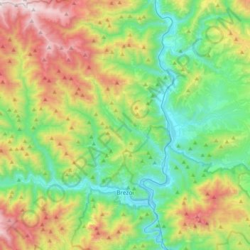
Name: Brezoi topographic map, elevation, terrain.
Location: Brezoi, Vâlcea, Romania (45.29185 24.06977 45.51509 24.36018)
Average elevation: 865 m
Minimum elevation: 298 m
Maximum elevation: 2,030 m
Other topographic maps
Click on a map to view its topography, its elevation and its terrain.