
Levoča topographic map
Interactive map
Click on the map to display elevation.
About this map
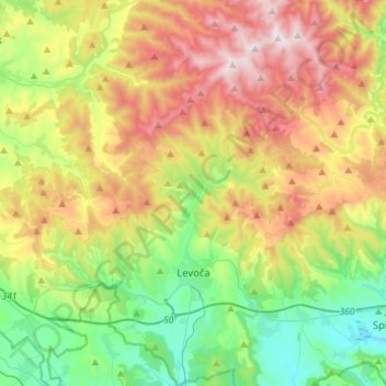
Name: Levoča topographic map, elevation, terrain.
Average elevation: 745 m
Minimum elevation: 425 m
Maximum elevation: 1,238 m
The economic importance of the town was further diminished in 1871 when the important new Košice–Bohumín Railway was built just 8 km (5.0 mi) to the south, bypassing Levoča and going through the nearby town of Spišská Nová Ves. Later, in 1892, only a spur line was built from Spišská Nová Ves railway station to Levoča. Erwin Raisz, a famed cartographer who immigrated to the United States after earning a degree in engineering and architecture from the University of Hungary and after serving in WWI, was born in Levoča in 1893. Raisz learned about map making from his father, also a civil engineer, and was no doubt inspired by the topography of his homeland to create a unique hand-drawn method of portraying physiographic features. He taught at Harvard University and wrote the first cartography textbook in English.
Other topographic maps
Click on a map to view its topography, its elevation and its terrain.
Spišské Podhradie
Slovakia > Region of Prešov > District of Levoča
Spišské Podhradie, District of Levoča, Region of Prešov, Eastern Slovakia, 053 04, Slovakia
Average elevation: 574 m