
Štefanová topographic map
Interactive map
Click on the map to display elevation.
About this map
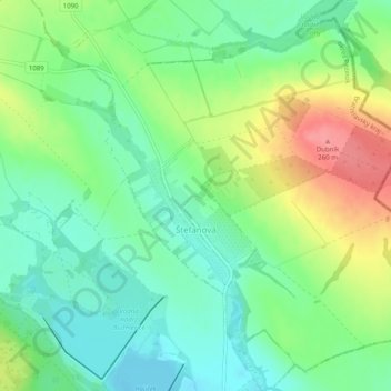
Name: Štefanová topographic map, elevation, terrain.
Location: Štefanová, District of Pezinok, Region of Bratislava, Slovakia (48.37181 17.38137 48.40193 17.43112)
Average elevation: 210 m
Minimum elevation: 180 m
Maximum elevation: 260 m
Other topographic maps
Click on a map to view its topography, its elevation and its terrain.
Vištuk
Slovakia > Region of Bratislava > District of Pezinok
Vištuk, District of Pezinok, Region of Bratislava, 900 85, Slovakia
Average elevation: 185 m
Častá
Slovakia > Region of Bratislava > District of Pezinok
Častá, District of Pezinok, Region of Bratislava, 900 89, Slovakia
Average elevation: 262 m
Pezinok
Slovakia > Region of Bratislava > District of Pezinok
Pezinok, District of Pezinok, Region of Bratislava, Slovakia
Average elevation: 300 m