
Tryon topographic map
Interactive map
Click on the map to display elevation.
About this map
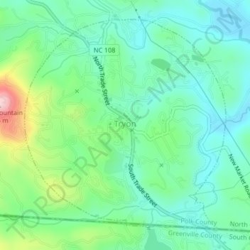
Name: Tryon topographic map, elevation, terrain.
Location: Tryon, Polk County, North Carolina, United States (35.19654 -82.25175 35.21942 -82.22512)
Average elevation: 333 m
Minimum elevation: 272 m
Maximum elevation: 498 m
The elevation of the town is 1,067 feet (325 m) above sea level. The town's original boundary was established as a circle with a radius of three quarters of a mile. According to the United States Census Bureau, the town has a total area of 1.8 square miles (4.7 km2), all land.
Other topographic maps
Click on a map to view its topography, its elevation and its terrain.
Peniel
United States > North Carolina > Polk County
Peniel, Polk County, North Carolina, 28722, United States
Average elevation: 326 m
Saluda
United States > North Carolina > Polk County
Saluda, Polk County, North Carolina, 28773, United States
Average elevation: 635 m
Howard Gap
United States > North Carolina > Polk County
Howard Gap, Polk County, North Carolina, United States
Average elevation: 573 m