
Perryville topographic map
Interactive map
Click on the map to display elevation.
About this map
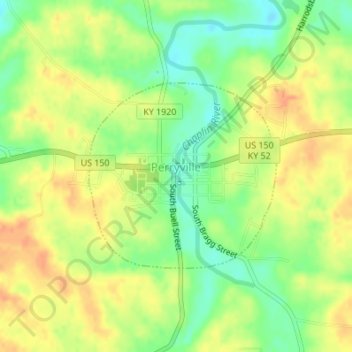
Name: Perryville topographic map, elevation, terrain.
Location: Perryville, Boyle County, Kentucky, United States (37.64256 -84.96008 37.65679 -84.94186)
Average elevation: 274 m
Minimum elevation: 252 m
Maximum elevation: 292 m
Other topographic maps
Click on a map to view its topography, its elevation and its terrain.
Danville
United States > Kentucky > Boyle County
Danville, Boyle County, Kentucky, United States
Average elevation: 290 m
Junction City
United States > Kentucky > Boyle County
Junction City, Boyle County, Kentucky, United States
Average elevation: 312 m
Parksville
United States > Kentucky > Boyle County
Parksville, Boyle County, Kentucky, 40464, United States
Average elevation: 334 m
West Danville
United States > Kentucky > Boyle County > Danville
West Danville, Danville, Boyle County, Kentucky, United States
Average elevation: 296 m