
Sidoarjo topographic map
Interactive map
Click on the map to display elevation.
About this map
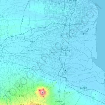
Name: Sidoarjo topographic map, elevation, terrain.
Location: Sidoarjo, East Java, Java, Indonesia (-7.58224 112.45669 -7.33021 112.88184)
Average elevation: 60 m
Minimum elevation: -3 m
Maximum elevation: 1,616 m
Other topographic maps
Click on a map to view its topography, its elevation and its terrain.
Malang
Indonesia > East Java > Kota Malang > Malang
The city was capital city of Singhasari in 1222, then transferred to Dutch colony. Malang was modernized under the Dutch; its mild climate which results from its elevation, along with its proximity to the major port of Surabaya, made it a popular destination for the Dutch and other Europeans. Malang began to…
Average elevation: 657 m
Kepanjen
Indonesia > East Java > Kabupaten Malang
Kepanjen is located in south center of Malang Regency. Kepanjen has an average altitude of 336 metres (1,102 ft) above sea level. Kepanjen is surrounded by three large mountains: Mount Kawi, Mount Semeru and Southern Malang Mountains.
Average elevation: 337 m
RW 11 Kelurahan Merjosari Kecamatan Lowokwaru Kota Malang
Indonesia > East Java > Kota Malang > Malang
Average elevation: 597 m
Babadan
Indonesia > East Java > Kabupaten Malang > Dsn. Babadan, Ds. Babadan, Kecamatan Ngajum, Malang
Average elevation: 561 m
Dusun Krajan Dkh Mboto RT 22 desa Kerjo Kecamatan karangan kabupaten Trenggalek Jawa timur
Indonesia > East Java > Trenggalek > Buluagung
Average elevation: 113 m