
Paro District topographic map
Interactive map
Click on the map to display elevation.
About this map
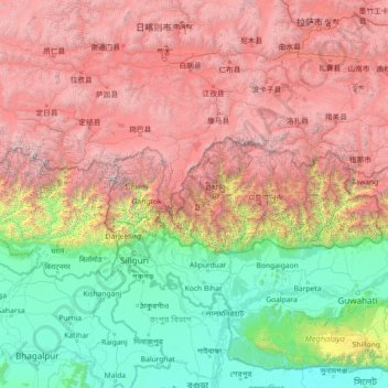
Name: Paro District topographic map, elevation, terrain.
Location: Paro District, Bhutan (24.90464 86.75834 30.02464 91.87834)
Average elevation: 2,636 m
Minimum elevation: 1 m
Maximum elevation: 8,299 m
Other topographic maps
Click on a map to view its topography, its elevation and its terrain.
Dopshar-ri Gewog
Dopshar-ri Gewog, Paro District, 12001, Bhutan
Average elevation: 2,829 m
Bondey
Bhutan > Paro District > Loong-nyi Gewog
Bondey, Loong-nyi Gewog, Paro District, 12001, Bhutan
Average elevation: 2,402 m
Khangkhu
Bhutan > Paro District > Khangkhu
Khangkhu, Paro Dzongkhag, Paro District, 12001, Bhutan
Average elevation: 2,454 m