
Santiago topographic map
Interactive map
Click on the map to display elevation.
About this map
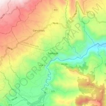
Name: Santiago topographic map, elevation, terrain.
Location: Santiago, Cantón Paraíso, Cartago Province, 30202, Costa Rica (9.83135 -83.84626 9.90788 -83.76642)
Average elevation: 1,275 m
Minimum elevation: 747 m
Maximum elevation: 1,935 m
The city lies in the center of the Santiago Basin, a large bowl-shaped valley consisting of broad and fertile lands surrounded by mountains. The city has a varying elevation, gradually increasing from 400 m (1,312 ft) in the western areas to more than 700 m (2,297 ft) in the eastern areas. Santiago's international airport, in the west, lies at an altitude of 460 m (1,509 ft). Plaza Baquedano, near the center, lies at 570 m (1,870 ft). Estadio San Carlos de Apoquindo, at the eastern edge of the city, has an elevation of 960 m (3,150 ft).
Other topographic maps
Click on a map to view its topography, its elevation and its terrain.
Parque Nacional Tapantí - Macizo Cerro de la Muerte
Parque Nacional Tapantí - Macizo Cerro de la Muerte, Cantón Paraíso, Cartago Province, Costa Rica
Average elevation: 1,837 m
Orosi
Orosi, Cantón Paraíso, Cartago Province, 30203, Costa Rica
Average elevation: 2,036 m
Cachí
Cachí, Cantón Paraíso, Cartago Province, 30204, Costa Rica
Average elevation: 1,254 m