
Witcombe topographic map
Interactive map
Click on the map to display elevation.
About this map
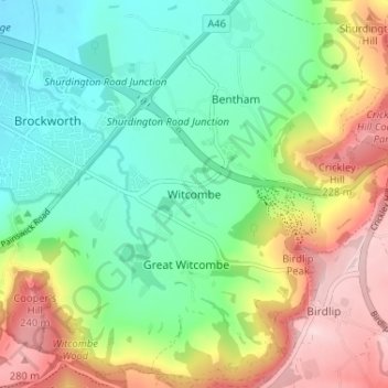
Name: Witcombe topographic map, elevation, terrain.
Average elevation: 140 m
Minimum elevation: 44 m
Maximum elevation: 302 m
Other topographic maps
Click on a map to view its topography, its elevation and its terrain.
Peak Plantation
United Kingdom > England > Gloucestershire > Tewkesbury > Witcombe
Peak Plantation, Great Witcombe, Witcombe, Tewkesbury, Gloucestershire, South West England, England, United Kingdom
Average elevation: 217 m