
Prince Islands topographic map
Interactive map
Click on the map to display elevation.
Prince Islands
All islands contain hills, the highest being Büyükada's Aya Yorgi Hill with 203 meters of elevation.
About this map
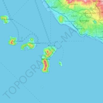
Name: Prince Islands topographic map, elevation, terrain.
Location: Prince Islands, Istanbul, Marmara Region, Turkey (40.81803 28.96917 40.91449 29.14822)
Average elevation: 12 m
Minimum elevation: -3 m
Maximum elevation: 218 m
Other topographic maps
Click on a map to view its topography, its elevation and its terrain.
Istanbul
Istanbul, located in northwestern Turkey, is a city that is uniquely situated across two continents, Europe and Asia, divided by the Bosphorus Strait. The city’s topography is characterized by a complex blend of hills, valleys, and coastal plains, which create a varied and scenic landscape. The European side…
Average elevation: 57 m