
Valencia topographic map
Interactive map
Click on the map to display elevation.
About this map
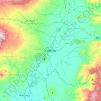
Name: Valencia topographic map, elevation, terrain.
Location: Valencia, Bukidnon, Northern Mindanao, 8709, Philippines (7.74288 124.92980 8.06288 125.24980)
Average elevation: 566 m
Minimum elevation: 222 m
Maximum elevation: 1,690 m
The city's topography is characterized as flat to undulating hills with extensive plateaus and mountainous areas and cliffs on both eastern and western portions bounding the municipality of San Fernando on the east and the municipality of Talakag on the west. Its highest point is Mount Kalatungan in the Kalatungan Mountain Range rising above 1,000 meters and above 50 percent slopes. These cover 25.72 percent of the total city area and major portions of Barangay of Lourdes, Guinoyuran and Lilingayon.