
Battle Hill topographic map
Interactive map
Click on the map to display elevation.
About this map
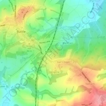
Name: Battle Hill topographic map, elevation, terrain.
Average elevation: 66 m
Minimum elevation: 17 m
Maximum elevation: 135 m
Other topographic maps
Click on a map to view its topography, its elevation and its terrain.
Battle of Hastings
United Kingdom > England > Rother
Battle of Hastings, Powdermill Lane, Catsfield, Rother, East Sussex, South East, England, TN33 0SZ, United Kingdom
Average elevation: 60 m
Rye
United Kingdom > England > Rother > Rye
Rye, Rother, East Sussex, South East, England, TN31 7LY, United Kingdom
Average elevation: 12 m
Battle
United Kingdom > England > Rother > Battle
Battle, Rother, East Sussex, South East England, England, TN33 0EA, United Kingdom
Average elevation: 64 m
Crowhurst
United Kingdom > England > Rother
Crowhurst, Rother, East Sussex, South East, England, United Kingdom
Average elevation: 42 m
Senlac Hill
United Kingdom > England > Rother
Senlac Hill, Rother, East Sussex, South East, England, TN33 0AQ, United Kingdom
Average elevation: 62 m
Camber Sands
United Kingdom > England > Rother
Camber Sands, Old Lydd Road, Camber, Rother, East Sussex, South East, England, TN31 7RE, United Kingdom
Average elevation: 1 m
Staplecross
United Kingdom > England > Rother > Staplecross
Staplecross, Rother, East Sussex, South East England, England, TN32 5FB, United Kingdom
Average elevation: 59 m
Salehurst
United Kingdom > England > Rother > Salehurst
Salehurst, Rother, East Sussex, South East England, England, TN32 5PH, United Kingdom
Average elevation: 40 m
Cock Marling
United Kingdom > England > Rother > Udimore > Cock Marling
Cock Marling, Udimore, Rother, East Sussex, South East England, England, TN31 6AN, United Kingdom
Average elevation: 19 m
Udimore
United Kingdom > England > Rother > Udimore
Udimore, East Sussex, South East, England, TN31 6AX, United Kingdom
Average elevation: 22 m
Dallington Forest
United Kingdom > England > Rother
Dallington Forest, Rother, East Sussex, South East, England, TN21 9JJ, United Kingdom
Average elevation: 107 m